Showing 200 items matching geological survey
-
 Federation University Historical Collection
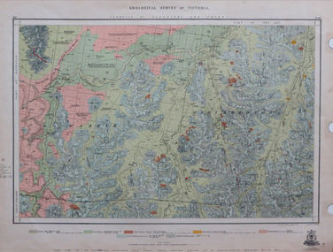
Map, Geological Survey of Victoria, 1913
... Geological Survey of Victoria...geological survey of victoria...Geological Survey of Victoria... Geological Survey of Victoria Printed colour map on paper victoria ...Printed colour map on papervictoria, geological survey of victoria, gladstone, talbot -
 Clunes Museum
Book, ROBERT S. BRAIN, BULLETINS OF THE GEOLOGICAL SURVEY OF VICTORIA, 1903
... BULLETINS OF THE GEOLOGICAL SURVEY OF VICTORIA...GEOLOGICAL SURVEY...DEPARTMENT OF MINES, GEOLOGICAL SURVEY OF VICTORIA...BOOK - "BULLETINS OF THE GEOLOGICAL SURVEY OF VICTORIA... BULLETINS OF THE GEOLOGICAL SURVEY OF VICTORIA BOOK - "BULLETINS ...BULLETINS OF THE GEOLOGICAL SURVEY OF VICTORIA, AUSTRALIA.BOOK - "BULLETINS OF THE GEOLOGICAL SURVEY OF VICTORIA.. NO. 6 THE CLUNES GOLDFIELD BY W M. BRADFORD.non-fictionBULLETINS OF THE GEOLOGICAL SURVEY OF VICTORIA, AUSTRALIA.local history, mining, geological survey -
Stawell Historical Society Inc
Map, Geological Survey Office, Sloanes & Scotchmans united Mine, December 1916
... Sloane & Scotchman's Geological Survey Map 1916 Showing...Geological Survey Office Ballarat December 1916 ...Geological Survey Office... Geological Survey Map 1916 Showing Underground Drives Geological ...Sloane & Scotchman's Geological Survey Map 1916 Showing Underground DrivesGeological Survey Office Ballarat December 1916 mining, gold, map -
Clunes Museum
GEOLOGICAL SURVEY, PROFESSOR. J.W.GREGORY, F.R.S, D.SC., DIRECTOR, CIRCA 1903
... GEOLOGICAL SURVEY...geological survey...BULLETINS OF THE GEOLOGICAL SURVEY OF VICTORIA... SURVEY BULLETINS OF THE GEOLOGICAL SURVEY OF VICTORIA NO 6 ...NO 6 THE CLUNES GOLD FIELDSBULLETINS OF THE GEOLOGICAL SURVEY OF VICTORIAlocal history, docoments, geological survey, mining -
 Federation University Historical Collection
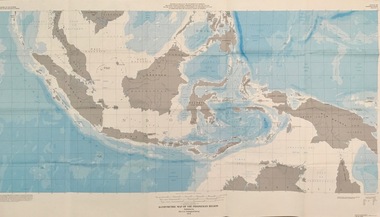
Map - Geological, U.S. Government Printing Office, Bathymetric Map of the Indonesian Region: Folio of the Indonesian Region Map I-875-A, 1974
... geological survey... of State in cooperation with the Geological Survey of Indonesia...The U.S. Geological Survey... of State in cooperation with the Geological Survey of Indonesia ...Map was prepared on behalf of the Government of Indonesia, The United Nations Economic Commission for Asia and the Far East, the Agency for International Development and the U.S. Department of State in cooperation with the Geological Survey of Indonesia. The area covered shows the islands and seas from Latitude 12 degree North to 16 degrees South and Longitude 90 degrees to 148 degrees. Various water features are also named.Large map showing the Indonesian area - islands and seasLongitude and Latitude are shown. Major / Capitol cities indicated. Names of those responsible for the productionindonesia, united nations economic commission, department of state, geological survey, latitude, longitude, government of indonesia -
 Federation University Historical Collection
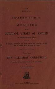
Book, Memoirs of the Geological Survey of Victoria No 14 The Ballarat Goldfields, 1923
... Memoirs of the Geological Survey of Victoria No 14 The...geological survey no 14... Book Memoirs of the Geological Survey of Victoria No 14 ...William Baragwanath was educated at the Ballarat School of Mines, obtaining a Geology Certificate in 1911. After further study he went on the become Secretary for Mines, and Chief Mining Surveyor. Baragwanath was a Councillor of the Ballarat School of Mine from 1916 to 1950.Pink covered foolscap book of 257 pages and 32 maps and plans by William Baragwanath. Contents include topography, physiography, historical, geology, basalt, faults, dykes, minerals leads, alluvial mines, nuggets, structure of Ballarat West goldfields, structure of Ballarat East gold-field, quartz formation, indicators, defunct mines, existing mines, table of deepest shafts. Images include: section of the Ballarat Gold-Field, Dead HOrse Flat, lakes formed by Basalt Flows, Gong Gong Creek, Frenchman's Lead, Ballarat West Mines, LEases and positions of shafts (1857), puddling, White Horse Lead, Woah Hawp Canton, Ballarat Township mines, Sebastopol, syncline, Victoria United Line, First Chance Mine, Llanberris No 1 Mine, Saddle Reef, New Normanby Mine, Woah Hawp Canton Mine, South Star Mine, Sebastopol Plateau, south Woah Hawp Mine, Woah No. 2 Minegeology, geological survey no 14, ballarat, baragwanath, william baragwanath -
 Federation University Historical Collection
Book, William Baragwanath, Memoirs of the Geological Survey of Victoria No 14: The Ballarat Goldfield, 1923
... Memoirs of the Geological Survey of Victoria No 14: The...geological survey of victoria... Memoirs of the Geological Survey of Victoria No 14: The Ballarat ...257 page foolscap pink covered book relating to the Ballarat goldfields plus 32 plates of maps and sections. william baragwanath, mining, geological survey of victoria, ballarat, goldfields, raglan street, ballarat -
 Federation University Historical Collection
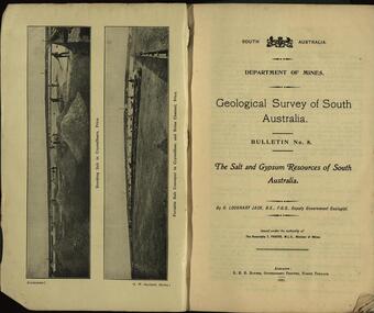
Booklet, Geological Survey of South Australia: The Salt and Gypsum Resources of South Australia, 1921
... Geological Survey of South Australia: The Salt and Gypsum...geological survey... Geological Survey of South Australia: The Salt and Gypsum Resources ...A South Australian Department of Mines report on salt and gylpsum resources in the state. geological survey, south australia, gypsum, salt, resources, department of mines -
 Federation University Historical Collection
Book, Memoirs of the Geological Survey of Victoria No 11. The Maryborough Goldfield, 1913
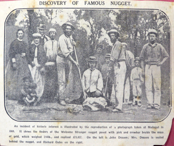
... Memoirs of the Geological Survey of Victoria No 11. The...memoirs of the geological survey of victoria... Memoirs of the Geological Survey of Victoria No 11 ...Pink soft covered book of 76 pages and 7 plates. Includes two loose newsclips .2) The Larkinville Nugget (The Age 21 Jan 1931) .3) Discovery of the Welcome Nuggetmaryborough, memoirs of the geological survey of victoria, d.j. mahony, maryborough goldfield, geology, faults, welcome nugget, richard oates, mrs deason, moliagul, larkinville nugget, m. larcombe, john deason, eucalypts -
Koorie Heritage Trust
Book, Baragwanath, W, Memoirs of the Geological Survey of Victoria : No. 15 The Aberfeldy District, Gippsland, 1925
... Memoirs of the Geological Survey of Victoria : No. 15 The... -- Victoria. I. Geological Survey of Victoria. II. Victoria. Dept. of.... Geological Survey of Victoria. II. Victoria. Dept. of Mines ...15 v. : ill., plates, maps, plans, diagrs. ; 34 cm. lcsh: 1. geology -- victoria -- periodicals. 2. geology -- victoria. i. geological survey of victoria. ii. victoria. dept. of mines. -
 Kiewa Valley Historical Society
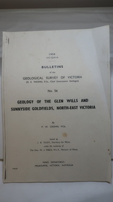
Document - Four Geological reports on the North-east Goldfields, Geological Survey of Victoria 1958 Bulletin
... Geological Survey of Victoria 1958 Bulletin...Geological Surveys of N.E. Goldfields Victoria included... Printer, Mines Department, Melbourne, Victoria Geological Surveys ...Geological Surveys of N.E. Goldfields Victoria included mines and tunnels. A resurvey of goldfields was necessary to re-assess economic possibilities using modern techniques and structural interpretation. It included an examination of a considerable surface area with maps and underground workings. Results were correlated and integrated and published by the Mines Department.The mines are in the Bogong Alpine Area.Foolscap printed Victorian Bulletins. Each stapled in the top left corner and each with varying number of pages. Covering 1941-1958 a) Glen Wills and Sunnyside b) Sunnyside Tunnel c) Red Robin d) Maud and Yellow Girl Government Printer, Mines Department, Melbourne, Victoriageology in the north-east, gold fields, goldmines, glen wills -
 Federation University Historical Collection
Map, Ballaarat Gold Field, 1861
... by the Geological Survey of Victoria. In November 2004 the Central...Geological Survey of Victoria... by the Geological Survey of Victoria. In November 2004 the Central ...A party of surveyors camped by Yuille's Swamp (later Lake Wendouree) and surveyed the countryside for a map to be produced by the Geological Survey of Victoria. In November 2004 the Central Highlands Regional Library presented a special edition of 200 copies of the 1861 map reproduced from a copy in their collection. Original 1861 map of Ballarat showing streets and leads. Blue dots indicate gold leads, and red lines indicate auriferous quartz reef and outcrops of quartz veins."Compiled & Drawn from the Survey of Mining Surveyors Davidson, Fitzpatrick and Cowan & the Plans in the Surveyor General's Office by J. Brahe, 21st October 1861. R. Brough Smyth, Secretary for Mines. The Honourable J.B. Humffray, M.L.A. Commr of Mines.”ballarat, map, ballarat east, lake wendouree, survey, mines, robert davidson, ballarat gold field 1861, yuille's swamp, wendouree swamp, little bendigo diggings, gold leads, old post office hill, specimen hill, bakery hill, black hill, dead horse creek, brown hill, pennyweight hill, clayton hill, soldiers hill, golden point, gum tree flat, white flat, poverty hill, chinese village, robert brough smyth, ballarat map 1861, ballaarat vineyard, dead horse gully, deadhorse creek, invermay, black hill flat, gaelic church, police reserve, magpie range, dalton's flat, caadian lead, rifle butts, powder magazine, bathing house, government camp, gold office, chinese, llanberrris, victoria theatre, charlie napier hotel, united states hotel, grape's hoel, clayton's hill, cattleyard hill, free trade hotel, esmond lead, bakery hill, black hill lead, juvenile reformatory, ballarat orphanage, lady barkly lead, triffet's slaughter yard, little bendigo, melbourne road -
University of Melbourne, Burnley Campus Archives
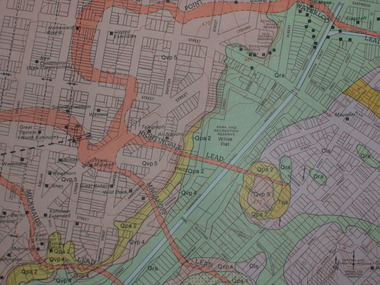
geological survey - Map, Maps of Geelong and Portarlington areas, 1963
... geological survey...geological survey... A. Coloured geological survey map of Geelong area: showing... Boulevard Richmond melbourne Map geological survey Maps of Geelong ...A. Coloured geological survey map of Geelong area: showing sedimentary and igneous rock formations and contours. B. Coloured geological survey map of Portarlington, Victoria. By Dept. Of Mines, Melbourne.geological survey, geelong, portarlington -
 Stawell Historical Society Inc
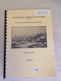
Book, Norman Taylor, Geological Survey of Victoria No3, Geological Survey of Stawell, 1875-1876
... Geological Survey of Victoria No3, Geological Survey of... grampians Book Geological Survey of Victoria No3, Geological Survey ...stawell mining -
 The Beechworth Burke Museum
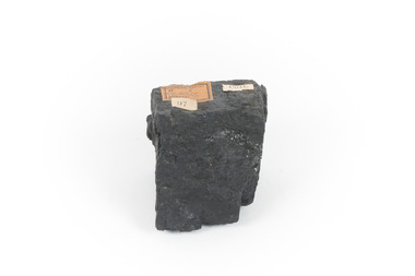
Geological specimen - Black Coal
... Geological Survey of Victoria...Geological survey / R..... S...../ Locality Cape Patterson ... with museum original label Geological survey / R..... S...../ Locality ...This specimen was recovered from Wonthaggi in Victoria. Coal is a sedimentary rock which is composed of peat after it has been exposed over millions of years. This is an example of Australian black coal which is used as either thermal or coking coal for electricity generation or manufacturing processes. It is predominantly composed of Carbon which is 'C' on the periodic table of elements. This early example of a coal sample, shows the important role that coal played/plays in Australia's energy generation and manufacturing processes. This specimen is part of a larger collection of geological and mineral specimens collected from around Australia (and some parts of the world) and donated to the Burke Museum between 1868-1880. A large percentage of these specimens were collected in Victoria as part of the Geological Survey of Victoria that begun in 1852 (in response to the Gold Rush) to study and map the geology of Victoria. Collecting geological specimens was an important part of mapping and understanding the scientific makeup of the earth. Many of these specimens were sent to research and collecting organisations across Australia, including the Burke Museum, to educate and encourage further study.Small piece of black coal with museum original labelGeological survey / R..... S...../ Locality Cape Patterson coal specimen, burke museum, geological survey of victoria, geological specimen, geology -
 Federation University Historical Collection
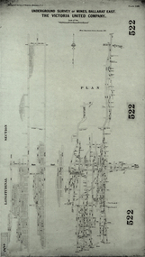
Plan, Underground Survey of Mines, Ballarat East. The Victoria United Company, 1903
... geological survey... Geological Survey of Victoria, Memoirs No. 4.... Geological Survey of Victoria, Memoirs No. 4. ballarat east, victoria ...Underground Survey of The Victoria United Company from Geological Survey of Victoria, Memoirs No. 4.ballarat east, victoria united company, cgt, mining, geological survey, longitudinal section -
 Federation University Historical Collection
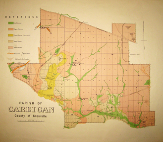
Map - Geological survey, Parish of Cardigan, County of Grenville, c1889
... Geological survey... Geological survey Map Parish of Cardigan, County of Grenville ...Geological map of the Parish of Cardigan on a cadastral base showing quartz reefs, shafts, alluvial deposits.cardigan, winter's creek, ballarat cattle yards railway, prince of wales park, ballarat, friendly societies reserve, ballarat industrial school reserve, green hill, bunker's hill, sago hill, diamond drill bores, cardigan propriety, half way house, ti tree creek, albion consols, prince imperial, winter's freehold company -
Tarnagulla History Archive
Bulletins of the Geological Survey of Victoria, no. 5 Dunolly Goldfield, 1903
... Bulletins of the Geological Survey of Victoria, no. 5... Commercial Rd Tarnagulla goldfields Bulletins of the Geological ...David Gordon Collection. -
Tarnagulla History Archive
Bulletins of the Geological Survey of Victoria, no. 17 the Newbridge Goldfield, 1905
... Bulletins of the Geological Survey of Victoria, no. 17 the... Commercial Rd Tarnagulla goldfields Bulletins of the Geological ...David Gordon Collection. -
Tarnagulla History Archive
Bulletins of the Geological Survey of Victoria, no. 17 the Newbridge Goldfield, 1905
... Bulletins of the Geological Survey of Victoria, no. 17 the... Commercial Rd Tarnagulla goldfields Bulletins of the Geological ...David Gordon Collection. -
Tarnagulla History Archive
Records of the Geological Survey of Victoria, Vol. 3, Part 1, 1909
... Records of the Geological Survey of Victoria, Vol. 3, Part... Commercial Rd Tarnagulla goldfields Records of the Geological Survey ...David Gordon Collection. -
Tarnagulla History Archive
Records of the Geological Survey of Victoria, Vol. 3, Part 1, 1909
... Records of the Geological Survey of Victoria, Vol. 3, Part... Commercial Rd Tarnagulla goldfields Records of the Geological Survey ...David Gordon Collection. -
Tarnagulla History Archive
Records of the Geological Survey of Victoria, Vol. 3, Part 1, 1909
... Records of the Geological Survey of Victoria, Vol. 3, Part... Commercial Rd Tarnagulla goldfields Records of the Geological Survey ...David Gordon Collection. -
Tarnagulla History Archive
Records of the Geological Survey of Victoria, Vol. 4, Part 1, 1921
... Records of the Geological Survey of Victoria, Vol. 4, Part... Commercial Rd Tarnagulla goldfields Records of the Geological Survey ...David Gordon Collection. -
Tarnagulla History Archive
Records of the Geological Survey of Victoria, Vol. 4, Part 1, 1921
... Records of the Geological Survey of Victoria, Vol. 4, Part... Commercial Rd Tarnagulla goldfields Records of the Geological Survey ...David Gordon Collection. -
Tarnagulla History Archive
Records of the Geological Survey of Victoria, Vol. 4, Part 1, 1921
... Records of the Geological Survey of Victoria, Vol. 4, Part... Commercial Rd Tarnagulla goldfields Records of the Geological Survey ...David Gordon Collection. -
 Ringwood and District Historical Society
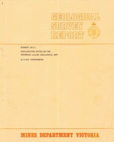
Booklet - Geological Survey Report, Explanatory Notes on Ringwood, Victoria by A.H.M. Vandenberg, 1971
... Geological Survey Report..., Victoria by A.H.M. Vandenberg Booklet Geological Survey Report ...Geological description of the eastern and southeastern suburbs of Melbourne, Dandenong Ranges, Harkaway Hills and the Silvan and Macclesfield districts. -
 Federation University Historical Collection
Plan, Ballarat Goldfield - Geological Survey of Victoria, 1981
... Ballarat Goldfield - Geological Survey of Victoria, 1981... Plan Ballarat Goldfield - Geological Survey of Victoria, 1981 ...Coloured geological plan showing the Ballarat goldfields. It includes coloured scales and nuggets from the Ballarat Goldfield. It also shows leads and mines.ballarat, geology, geological, gold nuggets, mining, mining companies, gold leads -
 Federation University Historical Collection
Plan, Ballarat Goldfields Geological Survey, 1981
... Ballarat Goldfields Geological Survey... Ballarat Goldfields Geological Survey Large coloured plan showing ...Large coloured plan showing streets, leads, geological zones and shafts. Source 1:10,000ballarat, gold, goldfield, geology, sebastopol -
 Federation University Historical Collection
Map - Geological, J. Phillips, Geological Survey of Victoria - Ballarat, 1857, 10/1858
... Geological Survey of Victoria - Ballarat, 1857... - Geological Geological Survey of Victoria - Ballarat, 1857 Geological ...Geological map of the Ballarat District featuring four colours.ballarat, geological, geology, geological plan